Home About the Stream The Partnership The Projects Research & Data News Archive Maps Links Contact Us

Research & Data

 Research & Data

 About SUDS

 Water Quality

 Hydrology

 Local Rainfall

 Student Papers

 WLMP

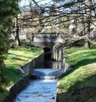
Branksome Wood Road Gauging WeirGauging Weir

The stream's only purpose-built gauging weir is at Branksome Wood Road.

It was constructed by Bournemouth Council's Drainage and Coast Protection Team in 1995/1996 at a cost of £53,750 which included works to the stream banks, the provision of a new timber footbridge and channel realignment works.

The weir is designed for a maximum discharge of 4.4m3/s (cubic metres per second) which gives a head of 0.85m above the crest of the weir.

On only one occasion in the last five years has the flow exceeded the maximum it was designed for.  That was in October 2001 - 143mm of rain during the month, 36.7mm of which fell on 7th October.

On average we experience two or three occasions annually where daily rainfall exceeds 30mm; the highest recently recorded was 31st December 2000 (49.1mm).

About Gauging Weirs

Measurement of flow rates in open channels is difficult because of non-uniform channel dimensions and variations in velocities across the channel. Weirs allow water to be routed through a structure of known dimensions, permitting flow rates to be measured as a function of depth of flow through the structure. Thus, one of the simplest and most accurate methods of measuring water flow in open channels is by the use of weirs.

In its simplest form, a weir consists of a bulkhead of timber, metal, or concrete with an opening of fixed dimensions cut in its top edge. This opening is called the weir notch; its bottom edge is the weir crest; and the depth of flow over the crest (measured at a specified distance upstream from the bulkhead) is called the head (H). The overflowing sheet of water is known as the nappe.

Two types of weirs exist:

  • Broad-crested weirs are commonly incorporated in hydraulic structures of various types and, although sometimes used to measure water flow, this is usually a secondary function.

  • Sharp-crested weirs and broad-crested weirs. A typical sharp-crested weir is illustrated below. The sharp edge in the crest causes the water to spring clear of the crest, and thus accurate measurements can be made.

.

Adapted from: Weirs for Open-Channel Flow Measurement by Allen G. Smajstrla and Dalton S. Harrison, 2002. 


About the Stream • The Partnership • The Projects • Research & Data • News Archive • Maps • Links • Contact Us


Borough of Poole | Bournemouth Borough Council | Environment Agency | Sembcorp Bournemouth Water | Wessex Water Natural England | Bournemouth University | Greenlink | Bournemouth Oceanarium | Dorset Wildlife Trust | Dorset Coast Forum

Copyright © 2000-2012 Bourne Stream Partnership.  All rights reserved.


Disclaimer and copyright